| Start |
End |
Tot Dist
Miles |
Leg Dist
Miles
|
Access Notes |
Egress Notes |
Rapids/High Water Notes |
Other Notes |
|
|
Abertridwr Bridge |
1.0 |
1.0 |
Access via Car Park RT. Also via B4393 on left side or road (River LT) before DAM
 |
|
|
|
|
|
Felin Graig |
1.7 |
0.7 |
|
|
|
|
|
|
Cownwy Bridge / Confluence |
2.8 |
1.1 |
|
RT after gorge - use for inspection after rapids. Portage LT with permission through private garden! Portage RT but longer. |
The Jacozzi waterfall is only shootable on the RT in high water when Grade III/IV. There is a short gorge following. |
|
Cownwy Bridge
/ Confluence |
|
Sawmill
(site of old bridge) |
4.2 |
1.4 |
Use ford above |
|
|
|
Sawmill
(site of old bridge) |
|
Pont Llogel bridge |
5.0 |
0.8 |
|
|
|
|
|
|
Plas Dolanog bridge |
7.4 |
2.4 |
LT before bridge from campsite. Additional access LT at picnic site. |
|
|
|
|
|
Dolanog Bridge |
8.1 |
0.7 |
|
|
|
|
|
|
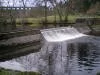
Dolanog Falls |
8.2 |
0.1 |
|
|
Grade III rapid folllowed by mill pool. |
|
|
|
Farm bridge |
8.3 |
0.1 |
|
|
DANGEROUS |
|
|
|
Dolanog Gorge start |
8.4 |
0.1 |
|
|
In high water - no headroom or bridge is covered. |
|
|
|
Pontrobert bridge |
11.8 |
3.4 |
Via road RT. Some parking |
|
INSPECT at high water |
|
|
|
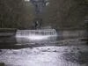
Weir and bridge |
13.3 |
1.5 |
|
|
From here downstream reaches are wide and have flat Grade I water but when in flood, it moves fast and has danger from overhanging trees. |
|
|
|
A495 bridge |
14.8 |
1.5 |
Good LT before bridge |
|
Placid section starts here. Parking on verges - take care on blind bends. Also check for double-yellow lines |
|
|
|
New Bridge
Banwy confluence |
14.9 |
0.1 |
LT before bridge |
|
|
|
New Bridge
Banwy confluence |
|
Mill |
15.3 |
0.4 |
|
|
|

|
|
|
Meifod reach |
16.3 |
1.0 |
Access to footpath - long portage |
|
|
|
|
|
Cil Mawr |
19.5 |
3.2 |
RT before bridge |
|
Meanders with islands and ox-bows |
|
|
|
Pontysgawrhyd
A490 |
21.0 |
1.5 |
|
|
|
|
|
|
Godor footbridge |
23.5 |
2.5 |
LT after bridge |
|
Four islands follow |
|
|
|
Confluence R. Cain |
27.0 |
3.5 |
RT before and over bridge towards A495. Small lay-by |
|
|
|
|
|
Llansanfraid
Bridge B4393 |
27.1 |
0.1 |
|
|
Glan Vyrnwy |
|
Llansanfraid
Bridge B4393 |
|
Confluence R. Tanat |
28.3 |
1.2 |
RT after |
|
|
|
|
|
Bridge A4398 |
30.3 |
2.0 |
|
|
|
|
|
|
Llanymynech
Bridge A843 |
32.0 |
1.7 |
RT before through field to camp site. After to Canal aqueduct |
|
|
|
|
|
Old Ford |
35.0 |
3.0 |
|
|
|
|
|
|
Sychpwll |
38.7 |
3.7 |
|
|
|
|
|
|
Haimwood Farm
(RT) |
39.3 |
0.6 |
|
|
|
|
|
|
Melverley Inn
(LT) |
41.3 |
2.0 |
|
|
|
|
|
|
Confluence
R. Severn |
42.0 |
0.7 |
|
|
|
|
|
|
|
|
|
|
|
|
|